Hurricane Lee now a Category 2 storm, but is forecast to restrengthen in the coming days

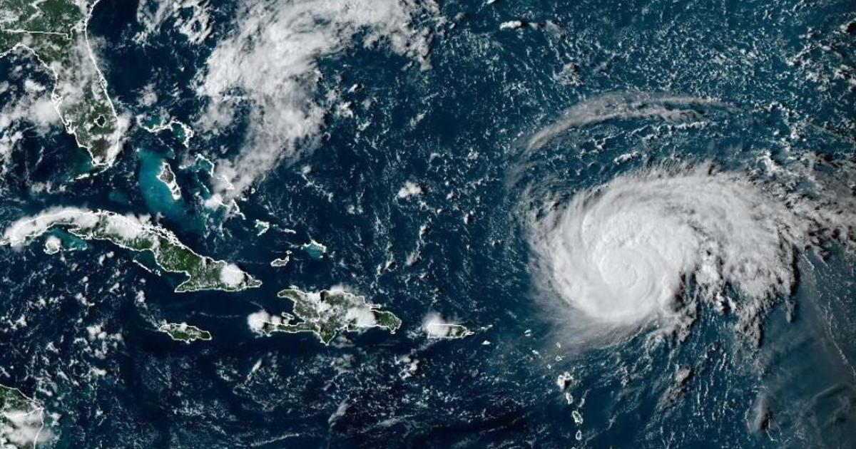
Hurricane Lee, which became the season’s first Category 5 storm Thursday night, had weakened to a Category 2 storm by Saturday as it continued to churn its way west through the warm waters of the Atlantic, the National Hurricane Center said.
Despite weakening, the hurricane center warned that Lee was “expected to grow in size over the next few days.”
“Dangerous surf and rip currents are expected to begin along most of the U.S. East Coast” starting on Sunday and then “worsen through the week,” the hurricane center added.
The center also said that the storm could experience “gradual restrengthing during the next couple of days.”
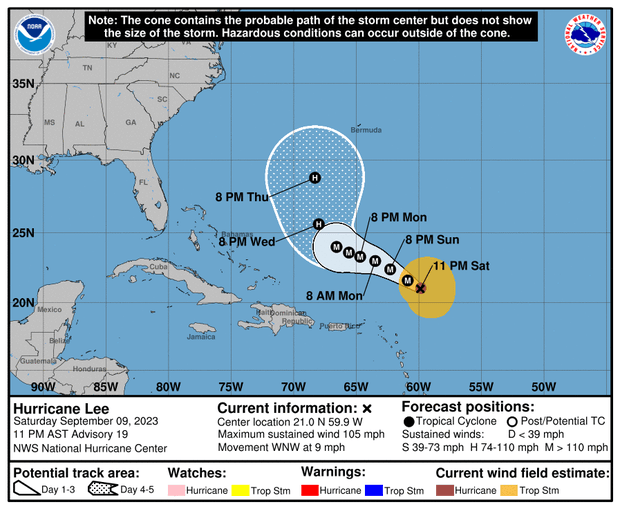
As of 11 p.m. EDT on Saturday, Lee had maximum sustained winds of 110 mph, down significantly from the 150 mph winds it reached on Friday. Its center was about 285 miles northeast of the northern Leeward Islands, and it was traveling west-northwest at 9 mph over the Atlantic. The Leewards are a group of islands where the Caribbean Sea meets the western Atlantic Ocean.
Large ocean swells generated by Lee were affecting the Lesser Antilles Saturday, and would reach the U.S. and British Virgin Islands, Puerto Rico, the Bahamas, Bermuda, the Turks and Caicos Islands and Hispaniola throughout the weekend, the hurricane center said.
“These swells are likely to cause life-threatening surf and rip current conditions,” but Lee’s center is forecast to pass “well to the north” of those islands, the agency said.
NOAA / National Weather Service
The long-term track for Lee remains unclear as meteorologists continue monitoring the storm for signs it could shift over the open ocean and turn more toward the U.S. coast, with questions circulating about the path it could take.
CBS News senior weather and climate producer David Parkinson said Friday that the chances of Lee hitting land were below 2% from New Jersey on south; below 10% for Long Island, Connecticut, Rhode Island and Massachusetts; and below 20% for northern New England, adding that forecasters will have a much clearer picture of Lee’s likely path by the middle of next week.
Parkinson laid out a few possible scenarios for Lee. One would involve a cold front coming off the East Coast that could trap Lee and push it north against the coastline, bringing potentially stormy weather to areas along the coast.
However, if no cold front forms, Parkinson explained, Lee would then potentially stay out at sea for a longer period until it reaches Newfoundland and Labrador in Canada. By that point, it may be significantly weakened.
Chris Warren, meteorologist for The Weather Channel, also said Friday that a jet stream that is currently dipping south could help determine whether Lee goes “well away from land, or much closer.”
Warren added that “regardless” of Lee’s path, it will still bring “large waves and dangerous rip currents up and down the East Coast.”
As meteorologists predicted, Lee gained strength quickly. Early Wednesday, Lee was a tropical storm with sustained winds of 65 mph — but grew within hours into a Category 1 hurricane on the Saffir-Simpson scale when it reached maximum sustained wind speeds of 74 mph. The following day it exploded from Category 2 to Category 4 and then all the way to Category 5, meaning sustained wind speeds of 157 mph or higher.
Meteorologists consider storms that fall within Categories 3, 4, or 5 to be “major” hurricanes, due to their potential to cause “significant loss of life and damage,” the National Hurricane Center says, warning that “catastrophic damage will occur” from a Category 4 or 5 making landfall.
Officials have not yet issued any storm or hurricane watches or warnings for places that could be in Lee’s path.
Lee’s emergence comes just days after Hurricane Idalia left a path of destruction across the Southeast.
That storm made landfall in Florida, where it razed homes and downed power poles. It then headed northeast, slamming Georgia, flooding many of South Carolina’s beachfronts and sending seawater into the streets of downtown Charleston. In North Carolina, it poured more than 9 inches of rain on Whiteville, flooding downtown buildings.
Idalia claimed at least two lives, one in Florida and the other in Georgia.
Idalia’s impact from damage and lost economic activity is expected to be in the $12 to $20 billion range, according to Moody’s Analytics.
Summarize this content to 100 words Hurricane Lee, which became the season’s first Category 5 storm Thursday night, had weakened to a Category 2 storm by Saturday as it continued to churn its way west through the warm waters of the Atlantic, the National Hurricane Center said.Despite weakening, the hurricane center warned that Lee was “expected to grow in size over the next few days.” “Dangerous surf and rip currents are expected to begin along most of the U.S. East Coast” starting on Sunday and then “worsen through the week,” the hurricane center added.
The center also said that the storm could experience “gradual restrengthing during the next couple of days.”As of 11 p.m. EDT on Saturday, Lee had maximum sustained winds of 110 mph, down significantly from the 150 mph winds it reached on Friday. Its center was about 285 miles northeast of the northern Leeward Islands, and it was traveling west-northwest at 9 mph over the Atlantic. The Leewards are a group of islands where the Caribbean Sea meets the western Atlantic Ocean.
Large ocean swells generated by Lee were affecting the Lesser Antilles Saturday, and would reach the U.S. and British Virgin Islands, Puerto Rico, the Bahamas, Bermuda, the Turks and Caicos Islands and Hispaniola throughout the weekend, the hurricane center said.”These swells are likely to cause life-threatening surf and rip current conditions,” but Lee’s center is forecast to pass “well to the north” of those islands, the agency said.
The latest projections for Hurricane Lee as it moves across the Atlantic Ocean. Sept. 9, 2023.
NOAA / National Weather Service
The long-term track for Lee remains unclear as meteorologists continue monitoring the storm for signs it could shift over the open ocean and turn more toward the U.S. coast, with questions circulating about the path it could take.CBS News senior weather and climate producer David Parkinson said Friday that the chances of Lee hitting land were below 2% from New Jersey on south; below 10% for Long Island, Connecticut, Rhode Island and Massachusetts; and below 20% for northern New England, adding that forecasters will have a much clearer picture of Lee’s likely path by the middle of next week.
Parkinson laid out a few possible scenarios for Lee. One would involve a cold front coming off the East Coast that could trap Lee and push it north against the coastline, bringing potentially stormy weather to areas along the coast.However, if no cold front forms, Parkinson explained, Lee would then potentially stay out at sea for a longer period until it reaches Newfoundland and Labrador in Canada. By that point, it may be significantly weakened.Chris Warren, meteorologist for The Weather Channel, also said Friday that a jet stream that is currently dipping south could help determine whether Lee goes “well away from land, or much closer.”Warren added that “regardless” of Lee’s path, it will still bring “large waves and dangerous rip currents up and down the East Coast.” As meteorologists predicted, Lee gained strength quickly. Early Wednesday, Lee was a tropical storm with sustained winds of 65 mph — but grew within hours into a Category 1 hurricane on the Saffir-Simpson scale when it reached maximum sustained wind speeds of 74 mph. The following day it exploded from Category 2 to Category 4 and then all the way to Category 5, meaning sustained wind speeds of 157 mph or higher.
Hurricane #Lee has explosively intensified into a Category 5 storm and is expected to peak as a monster 180 mph Cat 5. One of the fastest intensifying Atlantic hurricanes ever observed. pic.twitter.com/38efxc07Bj— Colin McCarthy (@US_Stormwatch) September 8, 2023
Meteorologists consider storms that fall within Categories 3, 4, or 5 to be “major” hurricanes, due to their potential to cause “significant loss of life and damage,” the National Hurricane Center says, warning that “catastrophic damage will occur” from a Category 4 or 5 making landfall.Officials have not yet issued any storm or hurricane watches or warnings for places that could be in Lee’s path.
Lee’s emergence comes just days after Hurricane Idalia left a path of destruction across the Southeast. That storm made landfall in Florida, where it razed homes and downed power poles. It then headed northeast, slamming Georgia, flooding many of South Carolina’s beachfronts and sending seawater into the streets of downtown Charleston. In North Carolina, it poured more than 9 inches of rain on Whiteville, flooding downtown buildings.Idalia claimed at least two lives, one in Florida and the other in Georgia. Idalia’s impact from damage and lost economic activity is expected to be in the $12 to $20 billion range, according to Moody’s Analytics.
Trending News
https://www.cbsnews.com/news/hurricane-lee-strengthens-atlantic-forecast/ Hurricane Lee now a Category 2 storm, but is forecast to restrengthen in the coming days


